and Chasing
[Index][Archives]
East Coast Low: Saturday 31st August 1996
by Michael Bath
| Storm News and Chasing [Index][Archives] |
East Coast Low: Saturday 31st August 1996 by Michael Bath |
From a few days prior to the east coast low, weather conditions were indicating a substantial rain event developing across eastern New South Wales and southern Queensland.
From the 26th to the 28th August a broad trough and surface low pressure had slowly moved from South Australia to the NSW south coast. However, a very active upper air disturbance remained in central Australia and a trough was developing in Queensland. Pressure patterns elsewhere were weak or not well defined. The Global Assimilation and Prediction System (GASP) computer model run for 7am on the 28th was predicting a surface low pressure to develop over land near the Queensland and New South Wales border area by Friday evening.
In Sydney on the 28th it was mostly cloudy consisting of cumulus and stratocumulus from the west. This cloud dissipated by early afternoon revealing some cirrus from the west-northwest. It was quite warm for a late Winter day with northwest winds and maximums of between 24 and 26 degrees Celsius (about 6 degrees above average). Later on in the day large cumulus redeveloped with cumulus congestus off the coast - indications of a fairly unstable atmosphere.
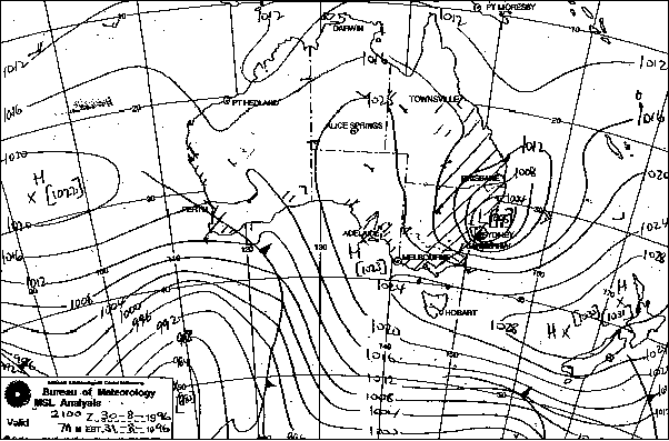
By noon of the 29th a high pressure system had established itself in the Bight with a secondary centre over Tasmania directing cooler southerly winds onto the eastern coast. The trough in Queensland had deepened but maintained its position. The upper air disturbance and the trough combined to produce an enormous cloud build up across central and eastern Australia within 24 hours. The GASP was now predicting a low to be located off the far NSW coast by Saturday and a high pressure system in the southern Tasman Sea. If the forecast was correct, this combination would produce torrential rain and gale force SE winds onto the coast.
At dawn in Sydney on the 29th it was mostly sunny in the west with cirrostratus streaming in from the northwest. Stratocumulus along the coast soon spread westwards with cool to cold, fresh southerly winds. By early afternoon it was overcast throughout the metropolitan area. The cloud was now large cumulus with stratocumulus and thickening upper level clouds. A few isolated light showers occurred.
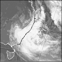
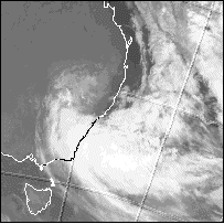
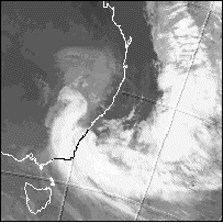
However, on the evening of the 29th and into the 30th, weather conditions deteriorated dramatically. Satellite imagery revealed that the cloud mass was becoming organised into a circulation centred over northern NSW. The northern part of the cloud band had contracted and curved south and clockwise from Queensland, while an enormous swirl curved west-northwestwards from the ocean, drawing in vast amounts of moisture. By evening the cloud mass had cleared most of western NSW and Queensland, had contracted and was focused into the low.
Synoptic charts showed a surface low analysed by 4am on the 30th, while the double centred high pressure remained relatively stationary, enhancing the moist east to southeast flow into the low. The low drifted slowly south, and during the early afternoon a second low centre formed off the far north coast of NSW. The two eventually combined into one intensifying system just off the NSW mid north coast by that evening. Central pressure of the low at 10pm on the 30th was already 1009 hPa.
Light rain had commenced throughout the metropolitan area before dawn on the 30th. Some moderate showers at sunrise were a sign of what was to come later that day. Drizzle persisted until early afternoon when light to moderate rainfalls commenced - coinciding with the low pressure forming off the coast north of Sydney. Cold conditions (maximums ranged from 12 to 15 degrees) and strengthening south to southeast winds prevailed. Cloud cover consisted of cumulus and stratocumulus with thick upper cloud bringing in the moisture. By evening, strong to gale force winds had commenced throughout the region and continuous moderate to heavy rain was falling.
Two characteristics of east coast lows are:
rapid intensification during the morning hours before dawn, and
a low pressure centre on or very close to the coast
This event was no exception. The low had centred itself just off or along the northern beaches of Sydney during the early hours of the 31st. This position resulted in most damage being confined to the most populated part of the NSW coast. Between 4am and 7am the central pressure of the low dropped 6hPa to 995hPa. It gradually dropped to 991hPa over the next 24 hours or so, however most of the destructive winds and heaviest rains in the region occurred before dawn on the 31st during the most rapid intensification of the system. The low moved very slowly south during the day and consequently, the heavier rain moved to the coastal regions south of Sydney by mid morning. It then expanded while maintaining a central pressure of 991hPa, then edged southeastwards by the next day, but gales continued over wide areas.
Maximum wind gusts to 160km/h and associated damage were focused on the coastal strip from Gosford to Nowra, and in the western suburbs of Sydney. In fact, sustained gusts at Glenmore Park (Penrith area) on the 31st were around 100km/h peaking at 130km/h on a few occasions.
Rainfall eased in coastal Sydney around dawn. Calm conditions with fog were observed over the northern suburbs, while at the same time, some of the strongest gusts were affecting the western suburbs. Squally showers persisted during the morning clearing by early afternoon - with a few more in the evening. Cloudy conditions continued all day in most parts.
Highest rainfall totals for the event occurred in the hilly terrain of northern Sydney and the Central Coast, and the Illawarra escarpment to the south. Official rainfalls totals exceeding 100mm for the 24 hours to 9am on the 31st August were:
260mm Darkes Forest
194mm Peats Ridge
189mm Mangrove Mountain
169mm Wyong
160mm Turramurra
154mm Belrose
150mm Cataract Dam
143mm Epping
135mm Frenchs Forest
127mm Sydney
124mm Concord
122mm Robertson
122mm Wollongong
121mm Homebush AWS
121mm Canterbury AWS
120mm Katoomba
117mm Cronulla
116mm Avalon
116mm Riverview
115mm Norah Head AWS
115mm Lucas Heights
115mm Oatley
114mm Mosman
111mm Glenorie
109mm Newport
108mm Sydney Airport
101mm Parramatta
100mm Randwick
Official rainfalls totals exceeding 100mm for the 24 hours to 9am on the 1st September were:
130mm Batemans Bay
111mm Kiama
102mm Darkes Forest
Insurance payouts as a result of the storm are estimated to be up to $50 million. Most damage is attributed to large trees falling onto property, while direct structural damage from the wind and rain also contributed significantly. Flooding of coastal streams was not a major contributor to the damage bill in this event, however many major roads were blocked for some time.
This was the most intense east coast low to affect the Sydney region since August 1990, although a similar event with a shorter duration occurred in September 1995.
from the Bureau of Meteorology
7am 31/8/1996
from the Bureau of Meteorology
10pm 30/8, 4am & 10am 31/8/1996
|
Document: 9608-01.htm
Updated: 6th April, 2004 |
[Australian Severe Weather index] [Copyright Notice] [Email Contacts] [Search This Site] |