and Chasing
[Index][Archives]
Sydney Storm Chase: Friday 13th November 1998
by David Croan
| Storm News and Chasing [Index][Archives] |
Sydney Storm Chase: Friday 13th November 1998 by David Croan |
After a fairly lean October, stormwise, in Sydney, things seemed to be returning to'normal' in November with spectacular storms moving through on the night of Saturday 7th. By Wedenesday of the following week, the models were hinting at the possibility for some Friday 13th storm action so I planned a 1/2 day off work just in case. On the day, the early forecast was also going for late storms and around noon, as I sorted through the mailing list messages, I was pleasantly surprised that based on the soundings, Paul Graham was confident that severe storms would be firing in eastern NSW and indeed conditions were at least favourable to the development of supercells. As I usually do, I headed up to the Beacon Hill lookout: decent storm systems to the Nth and Sth. some large cumulus to the west. I phoned Paul back at 3:30 pm and the chase was on.
During the 30 minute drive to Paul's house things were looking good with some large cumulus pushing the cap to the west. After picking up Paul, we decided to make a beeline for Rooty Hill. However, no sooner had we paid to M2 toll, that we both suspected that we were going to bust. Perhaps it was mainly as the air seemed to be clearing out in NW Sydney and beyond, but also after listening to the BoM 4:30 pm summary as there were no severe TS advices/warnings and nothing but a possible late thundery shower in Sydney. All the right ingredients were there but as Paul said, with thunderstorms you can't be sure of what to expect - and that you can't.
As we made it to western Sydney things were again looking up. Around 4:30pm several large congestus were going up right above us although everything seemed well capped - a good sign; if storms did develop they would probably be severe. We also observed some beautiful pileus and Paul pointed out a false funnel at the base of one of the large cumulus. I had my eye on one particular persistent congestus which appeared to finally break through a few km to our WSW and soon developed a nice updraft base. At this point, being around the corner (literally) from Rooty Hill, we decided to first see if Jimmy Deguara and Michael Bath were there before heading out after the developing storm. As we waited in a queue at a set of traffic lights we saw a familiar car headed in the opposite direction - It was Jimmy and Michael; they obviously had already sized up this development from Rooty Hill and were onto it. We had no chance of catching them but we weren't going to miss out. We turned around and headed Sth towards Horsley Park to keep in touch with the storm. We pulled off the road, checked our map and watched as the system moved to the ESE. Paul was detecting static crackles on the AM radio, a sure sign, and he navigated us towards the Horsely Hill lookout, where I observed a nice CG probably about 5 km away. As we topped the Hill I was surprised that the storm had really got going. We both got a few photos and watched the storm put out plenty of CGs and then a beautiful narrow but quite 'dense' rain curtain developed. I commented to Paul that Michael and Jimmy would be somewhere in the thick of it (they were!). The multicell development was propagating to the NW (towards us) and we were wary of some quite intense bolts of lightning which were getting a little too close for comfort. However, the overall SE movement of the system put us in the perfect position to view the intensifying storm to the SE at a close-but-safe distance. From the Horsley Hill, it was a fantastic site watching the storm mature with a probable microburst, a rain/hail shaft and swirling scud being drawn into the updraft - the convergence of scud under the updraft took on the appearance of a rotating base. And it may well have been as Michael and Jimmy who were right under the storm did observe a localised region of cloud base circulation [Interestingly, Michael Thompson who a few hours earlier and about 70 km south of us chased a storm which may have gone severe also observed and photographed an area of rotation (not thought to be mesocyclonic)]. At this stage (~5.30pm) the storm then seemed lose some punch in terms of the frequency of CGs and the appearance of the rain curtain and we were worried that cold outflow was going to take over and spoil our afternoon. As the storm edged further east we observed the rear section of the cumuliform anvil overhead and it appeared to be backsheared. More exciting was the new updraft which was developing to our immediate SE, again on the NW flank of the system. It was almost as though we were watching time lapse - you could clearly see the boiling updraft literally swell out. We were not aware of any warnings at the time but it clear that this was explosive development. At around 6:30 pm we watched as the cumulus to our west would show promising vertical growth then quickly dissipate and the unorganised development occurring right overhead did not seem to be going anywhere - at this point we probably would have been satisifed to call it quits after what we had already seen. However, our instincts told us to wait, and just as well - soon after another nice looking updraft began to develop to our west probably 5 km away. At around 6:45 pm, Jimmy and Michael soon arrived on the hill (after being in the thick of the storm we were watching) and we compared what we had all witnessed. Jimmy and Michael pointed out at least two very large storms probably 150+ km to the NNW - Paul and I were so engrossed in the Sydney development that we did not notice them. Based on their visual characteristics (boiling updraft, extensive anvil backshearing, relative isolation) they did look like supercells but I guess we'll never know.
The updraft base of the approaching second storm moved closer and, as with the first storm, was very spectacular. Precipitation broke through and we observed some nice CGs and a microburst as this second storm moved to within a few kms. At that stage the lightning was getting a little too close so I retreated to the safety of the car. It moved over our location with strong wind and heavy rain. Most spectacular was the lowered base which was revealed as the storm moved to our east - this was one of the most awesome sights I have ever witnessed (just check out the online photographs taken by Michael and Paul). We also saw a 'tail' cloud extending Nth from the rear section of the storm - I did not think it was an arcus clous as it seemed to be feeding into the updraft; perhaps an inflow stinger as this was about the time that the second warning was issued. To the S and SE was an immense rain curtain (we only copped to Nth edge). I was not at all surprised when I checked my messages the following morning to find that two severe thunderstorm warnings had been issued for southern suburbs of the Sydney metropolitan area. To top off a great afternoon/evening chase we were treated to a nice display of mainly anvil lightning before heading home at 8:00 pm.
Finally, a 'fairly heavy' lawn coverage of hail, which ranged from marble to 10c piece (~2.2 cm) diameter (which is probably bordering on severe limits), was reported by my family at their home in Padstow (Near Bankstown) in Sydney's SW. My brother, who observed the gust front from that location, described a roll cloud, extreme turbulence in that region and also commented that the storm 'looked' more severe to the south. This is consistent with media reports which mentioned golf ball (~4 cm) hail in suburbs to the S and SE of Padstow.
In summary a fantastic day and it was great to share it with other chasers.
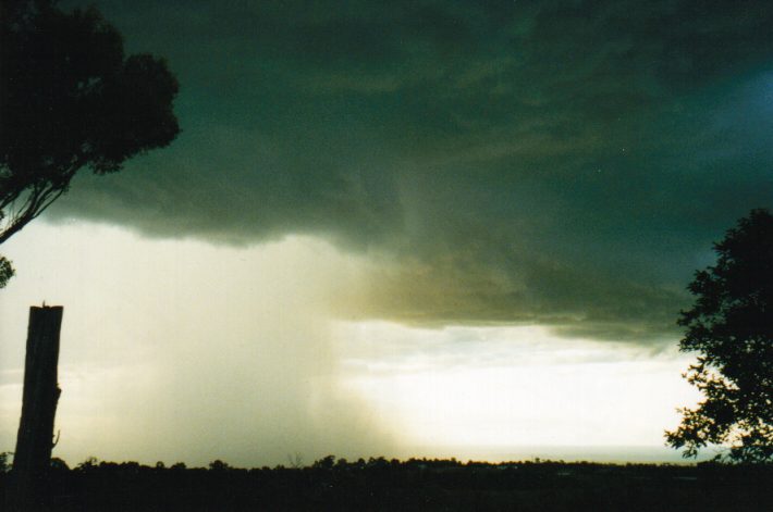
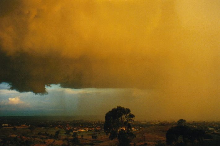
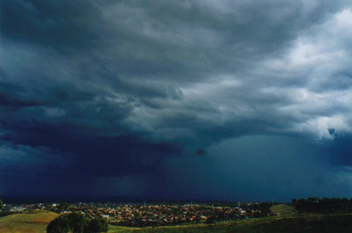 The first photo of the first storm taken from Horsley Hill. The rain and hail curtain developed very quickly and the storm was putting out plenty of CGs at this stage.
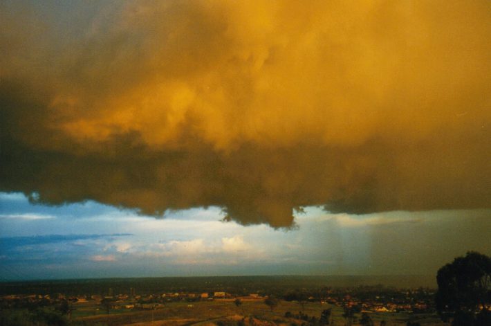
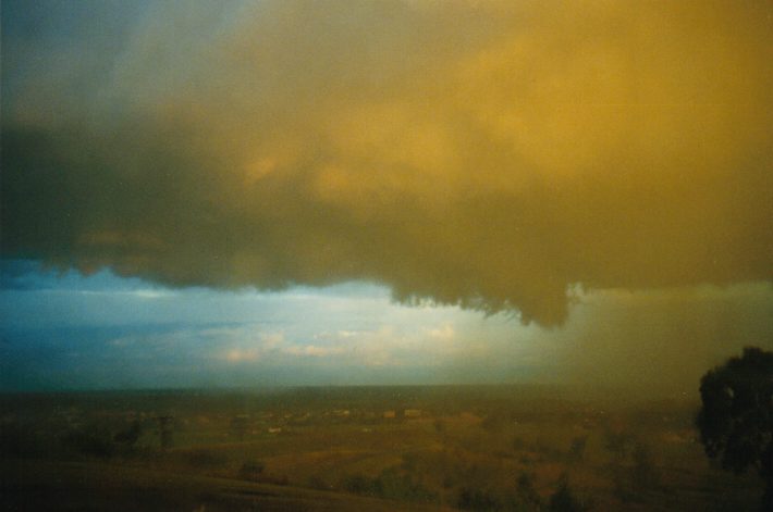
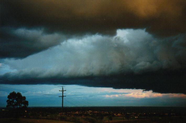
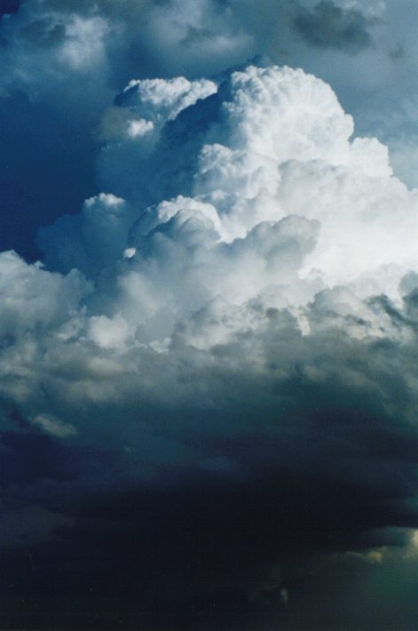 Rock hard updraft signifying explosive development on the NW flank at about 5.45pm
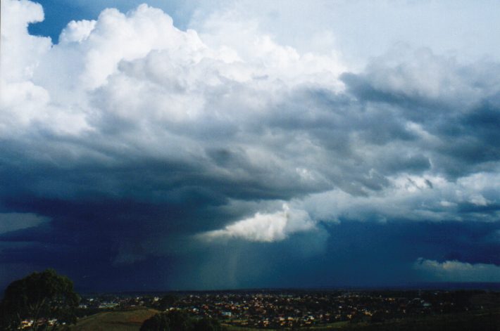
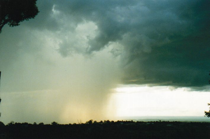
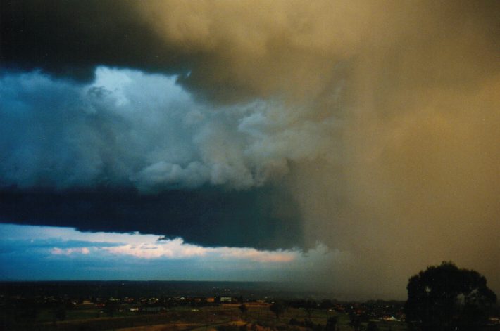
 Around 6pm: the storm had intensified further at this stage and showed nice structure. The movement of scud under the lowered region (between and above the two tree tops in the left of the picture) appeared to be convergent. Possible hail shaft and microburst observed at this stage. The back shearing anvil is also visible.
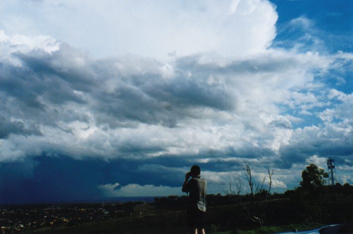
 (6:55 - 7:05pm) Early development of the second storm a few
km to our west. Note the gradual intensification of the cell to third picture in
which turbulent cloud tags and scud are seen under the updraft base and a
microburst had developed.
(6:55 - 7:05pm) Early development of the second storm a few
km to our west. Note the gradual intensification of the cell to third picture in
which turbulent cloud tags and scud are seen under the updraft base and a
microburst had developed.
 (7:20pm) The system looking east as it had past overhead and
showing the spectacular lowered base. It was still precipitating at our
location.
(7:20pm) The system looking east as it had past overhead and
showing the spectacular lowered base. It was still precipitating at our
location.

 (7:30pm) Looking east a few minutes later. Intense
precipitation was ocurring to the right and out of picture. The middle picture shows the north-extending cloud band which appeared to be feeding
into the updraft.
(7:30pm) Looking east a few minutes later. Intense
precipitation was ocurring to the right and out of picture. The middle picture shows the north-extending cloud band which appeared to be feeding
into the updraft.
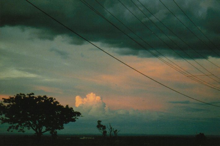 (7:40pm) Cell firing up to the north and illuminated by the
setting sun.
(7:40pm) Cell firing up to the north and illuminated by the
setting sun.
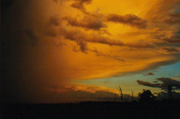 (8:00pm) The rear section of the highly backsheared anvil
spectacularly lit up by the sun. The storm appeared to be in decay at
this stage with the anvil taking on a more fibrous appearance.
(8:00pm) The rear section of the highly backsheared anvil
spectacularly lit up by the sun. The storm appeared to be in decay at
this stage with the anvil taking on a more fibrous appearance.
TOP PRIORITY FOR IMMEDIATE BROADCAST
SEVERE THUNDERSTORM WARNING
BUREAU OF METEOROLOGY
NEW SOUTH WALES REGIONAL OFFICE  Issued at 1834 on Friday the 13th of
November 1998

This warning affects people in the Sydney Metropolitan area.
This warning is current from 6:30pm until 7:30pm.

Storms are currently located near Sutherland and are forecast to move
towards the east reaching Cronulla within the next hour.

Large hailstones, destructive winds and very heavy rainfall are possible.
TOP PRIORITY FOR IMMEDIATE BROADCAST
SEVERE THUNDERSTORM WARNING
BUREAU OF METEOROLOGY
NEW SOUTH WALES REGIONAL OFFICE  Issued at 1958 on Friday the 13th of
November 1998
This warning affects people in the Sydney Metropolitan area.
This warning is current from 8:00pm until 9:00pm.

Storms are currently located near Bankstown and are forecast to move
towards the east reaching Botany Bay within the next hour.

Large hailstones, destructive winds and very heavy rainfall are possible.
|
Document: 9811-03.htm
Updated: 14th January, 2003 |
[Australian Severe Weather index] [Copyright Notice] [Email Contacts] [Search This Site] |